Pier Fire, Full Containment! 


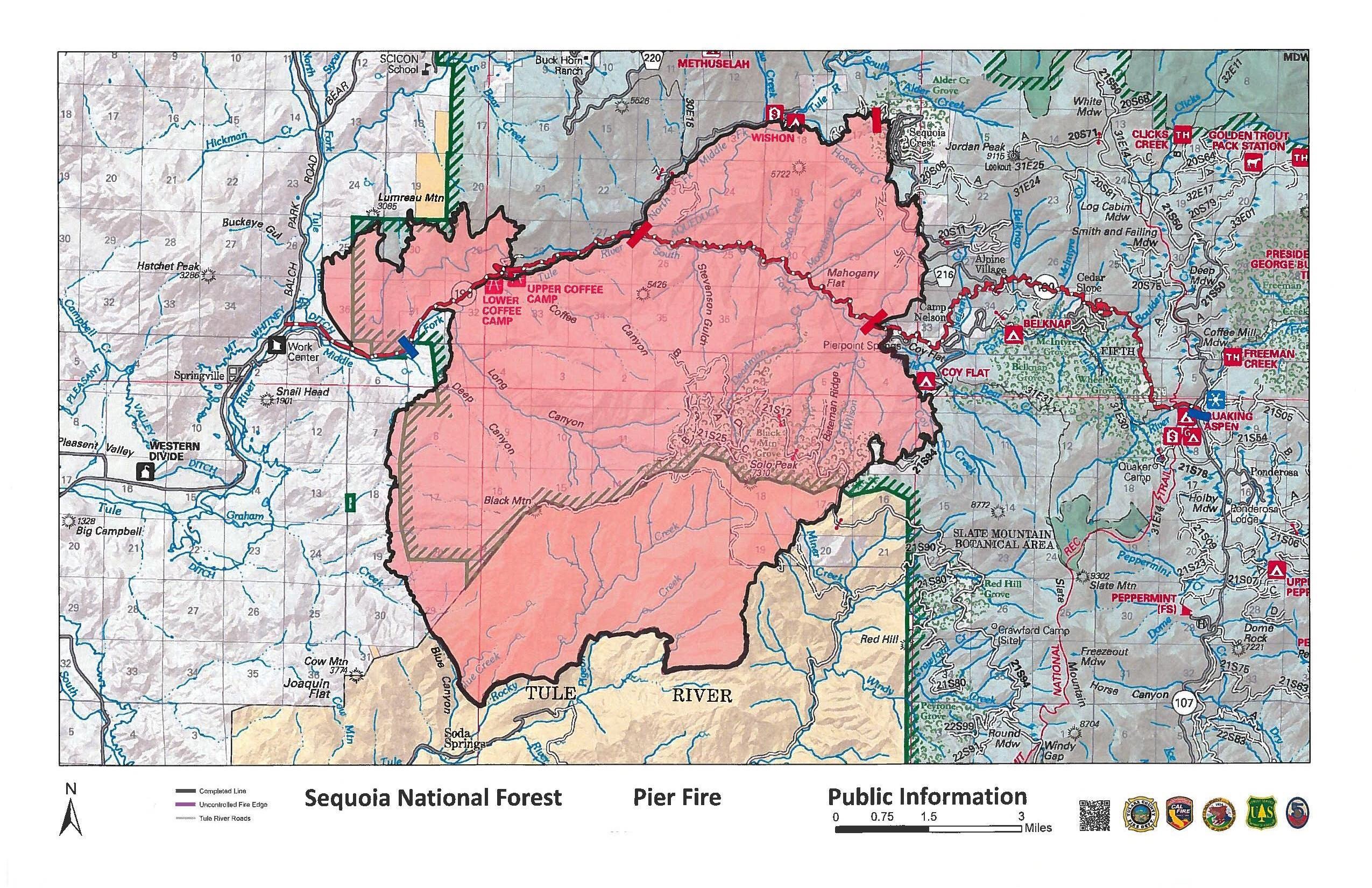
The Pier Fire has reached full containment at 36,566 acres. Full containment means that a perimeter line surrounds the fire keeping it from growing larger. 

Flames and smoke will continue to be seen from unburned pockets of vegetation burning well within containment lines, but escape potential remains low. 

Approximately 130 Sequoia National Forest personnel; 5 hand crews, 5 dozers, and miscellaneous overhead, continue to work on controlling the northern edge of the Pier Fire. Work is ongoing to monitor containment lines, extinguish remaining hot spots along the edge, complete suppression repair, and remove fire equipment. This work will continue until winter weather arrives and the Pier Fire can be declared out.

Similar efforts are ongoing on the Tule River Indian Reservation, where crews and heavy equipment work to mop up, control and repair that edge of the fire that burned onto Reservation lands. For additional information for activities along the southern edge of the Pier Fire, please call the Tule River Indian Reservation Fire Department (559) 784-1590.

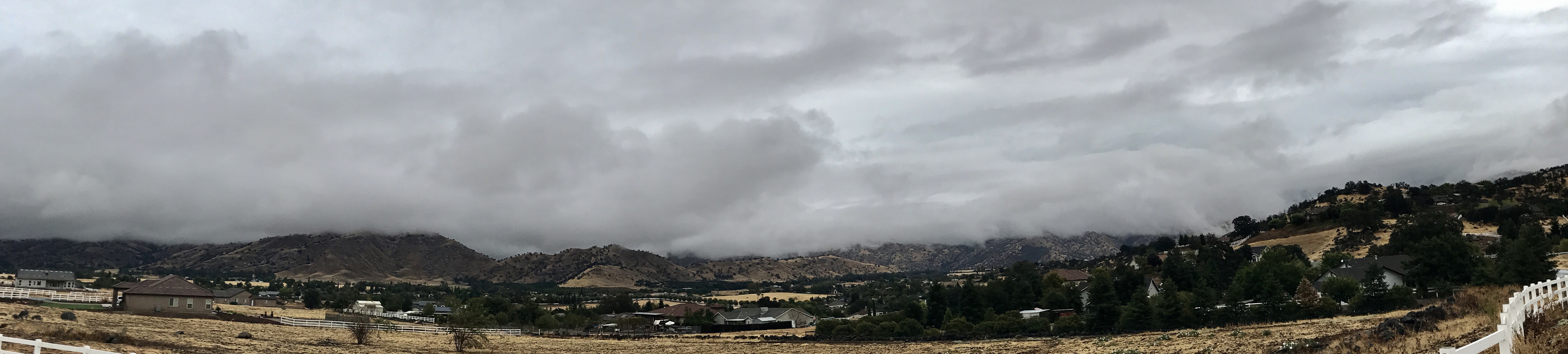
All travelers in the fire area should use extreme caution when driving. As winter weather arrives, conditions may worsen making roads impassable. Be aware of potential safety hazards such as falling rocks, mud and debris washed down from steep banks, and fire-weakened trees. The public, including local residents, are reminded that despite Highway 190 being reopened to access mountain communities, the Forest area and Forest Service roads remain closed under a Forest Closure Order due to hazardous conditions from the Pier Fire. 

Closure Order information and map for the area closed in Sequoia National Forest are available on Inciweb

Here are some of the more popular locations that are CLOSED for recreational use:

Upper and Lower Coffee Camp Day Use Areas, Wishon, Coy Flat, and Belknap Campgrounds, The “Stairs” and all turnouts along Highway 190 below Camp Nelson, Turnouts along County Road 208 into Wishon Campground, Fox Farm Road (FS20S03), and Forest road from Coy Flat to Rogers Camp (FS21S94)

As hazards are reduced, some areas may be reopened if conditions allow. For current recreational information, please call the Western Divide Ranger District at 559-539-2607 Monday through Friday 8:00 a.m. – 4:30 p.m.
Basic Information

Current as of 9/26/2017, 7:24:43 AM

Incident Type Wildfire

Cause Human (under Investigation)

Date of Origin Tuesday August 29th, 2017 approx. 02:30 AM

Location Highway 190 at Wishon Road 7 miles east of Springville

Incident Commander Ernie Villa

Current Situation

Total Personnel 130

Size 36,556 Acres

Percent of Perimeter Contained 100%

Estimated Containment Date Sunday September 24th, 2017 approx. 12:00 AM

Fuels Involved 

Primary fuels are dormant brush, hardwood slash, and closed timber litter.

Significant Events 

Fire suppression repair will continue.

Outlook

Planned Actions 

Continue suppression repair and remove fire equipment where no longer needed.

Projected Incident Activity 

Remarks 

Forest closure still in effect for Forest areas surrounding the Pier Fire.

Posted in fire, Fire Brigade, ponderosa | Tagged , , , , , , , , , , , , , , , | Leave a comment

Pier Fire Final Update 


The Pier Fire is 98% contained within fireline as of today. Firefighters will continue to extinguish remaining hot spots along the fire perimeter, suppression repair, and removal of fire equipment that is no longer needed. The public can still expect to see smoke and flame from hot spots well inside the burned area, but those will be extinguished with winter weather. The escape potential is low; perimeter lines will be patrolled by fire personnel as necessary.
All travelers in the fire area should use extreme caution when driving. Yesterdays rain showers increased the potential for hazardous conditions along the roadways. As winter weather arrives, conditions may worsen making roads impassable. Be aware of potential safety hazards such as falling rocks, mud and debris washed down from steep banks, and fire-weakened trees.
Southern California Edison is working to replace infrastructure that was damaged by the fire. Expect traffic delays when traveling along Highway 190. This work is necessary to have power restored to mountain communities.
Forest trails, roads, and lands around the Pier Fire remain closed under a Forest Closure Order. Closure Order information and a map are available on Inciweb 

The public, including local residents, are reminded that despite Highway 190 being reopened to access mountain communities, the Forest area and Forest Service roads remain closed due to hazardous conditions from the Pier Fire. 

For example, here are some of the more popular locations that are CLOSED for recreational use:

Upper and Lower Coffee Camp Day Use Areas

Wishon, Coy Flat, and Belknap Campgrounds

The “Stairs” and all turnouts along Highway 190 below Camp Nelson

Turnouts along County Road 208 into Wishon Campground

Fox Farm Road (FS20S03)

Forest road from Coy Flat to Rogers Camp (FS21S94)

As hazards are reduced, some areas may be reopened if conditions allow. This will be the final Pier Fire update. For current recreational information, please call the Western Divide Ranger District at 559-539-2607 Monday through Friday 8:00 a.m. – 4:30 p.m.
Basic Information

Current as of 9/22/2017, 9:32:44 AM

Incident Type Wildfire

Cause Human (under Investigation)

Date of Origin Tuesday August 29th, 2017 approx. 02:30 AM

Location Highway 190 at Wishon Road 7 miles east of Springville

Incident Commander Robert Benik (t) Ernie Villa

Current Situation

Total Personnel 287

Size 36,556 Acres

Percent of Perimeter Contained 98%

Estimated Containment Date Friday September 22nd, 2017 approx. 12:00 AM

Fuels Involved 

Primary fuels are dormant brush, hardwood slash, and closed timber litter. The fire is located in a heavy tree mortality area. The southern portion of the fire burned in a location with little to no recorded fire history.

Significant Events 

Rain showers made dirt roads impassable yesterday morning. As conditions change, fire suppression repair will continue.

Outlook

Planned Actions 

Continue suppression repair and remove fire equipment where no longer needed.

Projected Incident Activity 

Remarks 

No evacuations in place. Forest closure still in effect for Forest areas surrounding the Pier Fire.

Posted in fire, Photos, ponderosa | Tagged , , , , , , , , , , , , , , , , , | Leave a comment

Pier Fire Update, 9:40am, 9/21/27: RAIN! 

Black Mountain Cloaked in Rain/Fog
With wetting rains, firefighters will now focus their attention on suppression repair and removal of fire equipment no longer needed. Most of the dirt roads are unsafe to drive on with fire equipment, some areas may not be accessible unless conditions improve. Expect hot spots to continue to smolder well inside the burned area, but those will be extinguished if showers persist. The escape potential is low; perimeter lines will be patrolled by fire personnel as necessary.

All travelers in the fire area should use extreme caution when driving. Rain showers have increased the potential for hazardous conditions along the roadways. Be aware of potential safety hazards such as falling rocks, mud and debris washed down from steep banks, fire-weakened trees, and heavy equipment along roadways.

Southern California Edison is working to replace infrastructure that was damaged by the fire. Expect traffic delays when traveling along Highway 190. This work is necessary to have power restored to mountain communities.

Forest trails, roads, and lands around the Pier Fire remain closed under a Forest Closure Order. An updated Closure Order and map are available on Inciweb https://inciweb.nwcg.gov/incident/5548/

The public, including local residents, are reminded that despite Highway 190 being reopened to access mountain communities, the Forest area and Forest Service roads remain closed due to hazardous conditions from the Pier Fire.

For example, here are some of the more popular locations that are CLOSED for recreation:

Upper and Lower Coffee Camp Day Use Areas

Wishon, Coy Flat, and Belknap Campgrounds

The “Stairs” and all turnouts along Highway 190 below Camp Nelson that access the Tule River.

Fox Farm Road (FS20S03)

Forest road from Coy Flat to Rogers Camp (FS21S94)

As hazards are reduced, some areas may be reopened if conditions allow. The most up-to-date closure information will be posted on Inciweb as conditions change. For current recreational information, please call the Western Divide Ranger District at 559-539-2607 Monday through Friday 8:00 a.m. – 4:30 p.m.
Basic Information

Current as of 9/21/2017, 9:37:20 AM

Incident Type Wildfire

Cause Human (under Investigation)

Date of Origin Tuesday August 29th, 2017 approx. 02:30 AM

Location Highway 190 at Wishon Road 7 miles east of Springville

Incident Commander Robert Benik (t) Ernie Villa

Current Situation

Total Personnel 453

Size 36,556 Acres

Percent of Perimeter Contained 95%

Estimated Containment Date Wednesday September 20th, 2017 approx. 12:00 AM

Fuels Involved 

Primary fuels are dormant brush, hardwood slash, and closed timber litter. The fire is located in a heavy tree mortality area. The southern portion of the fire is burning in a location with little to no recorded fire history.

Significant Events 

Rain showers making dirt roads impassable by fire equipment.

Outlook

Planned Actions 

Continue suppression repair and remove fire equipment where no longer needed.

Projected Incident Activity 

Remarks 

No evacuations in place. Forest closure still in effect for Forest areas surrounding the Pier Fire.

Posted in fire, Fire Brigade, ponderosa | Tagged , , , , , , , , , , , , , , | Leave a comment

A beautiful Sunday walk through our mountains. 

Some photos and video from a Sunday walk from the Golden Trout Wilderness Pack Station down to 21S50, and a shot of the beautiful Quakin Aspen Meadow. 

The streams are still running! 


Posted in Hiking, ponderosa | Tagged , , , , , , , , , , , , , | Leave a comment