
Size: 20,529
Percent Contained: 20%
Fire Start: August 29, 2017
Location: Highway 190, east of Springville
Cause: Human caused, under investigation
Total Personnel: 1,416
Injuries: 3 minor injuries
Resources: 30 Crews, 6 Helicopters, 113 Engines, 21 Dozers, 13 Water Tenders
Today, officials downgraded evacuation orders for residents along Balch Park Road, Bear Creek area, Mountain Home State Forest, and SCICON area from mandatory to voluntary. All portions of Balch Park Road and Bear Creek Road will remain closed, however residents are able to enter showing proof of residency to posted law enforcement. Conditions may change in the next 36 hours for communities downgraded, causing officials to re-issue mandatory status if necessary. Returning residents should show caution, personal safety and be aware of possible debris and smoke inhalation.
The following communities remain under mandatory evacuation orders: Upper Rio Vista, Cow Mountain (Springville),Camp Nelson, Sequoia Crest, Mountain Aire (Rogers Camp), Cedar Slope, Alpine, Doyle Springs, Wishon, and Pierpoint. The following communities remain under voluntary evacuation: Springville and Ponderosa.
For further information in regards to Pier Fire evacuation orders and road closures please call the Tulare County EOC 559-623-0200.
Evacuation Center: Porterville College Student Center, 100 E. College Ave., Porterville. Call 661-324-6427 (weekdays) or 800-REDCROSS (1-800-733-2767) Provide food, shelter, arrange for animal care, and other basic needs for evacuees.
Fire Summary:
There was no change in acres burned or containment today, information will be updated Wednesday morning.
On the western portion of the fire, just east of Balch Park Road, firefighters made good progress putting in direct fireline along the fires edge. The Fox Farm Road east of Wishon continues to be the northern perimeter line, keeping the fire south of Wishon Campground and the community of Doyle Springs.
Work continues to improve contingency lines near Sequoia Crest, where several spot fires have tested the fire lines. The focus is now on improving the contingency lines from Sequoia Crest to HWY 190. Firing will take place to tie in the uncontrolled edge of the fire to the established contingency lines once they are completed. This effort will help to secure that edge of the fire.
Yesterday’s active fire along Bateman Ridge from HWY 190 up to Rogers Camp will need a lot of work by firefighters to hold that edge of the fire today. Indirect fire lines will be put in place because the vegetation in this area hasn’t burned in over 100 years. It is not safe for firefighters to work on the edge of the fire in this thick vegetation. Structure protection is ongoing where necessary. Once complete, firing will need to begin to secure that edge of the fire.
When fuel and weather conditions are favorable, firing will begin on the south and southwest edges of the fire. This effort will tie in the active fires edge into the indirect lines that have been well established by crews over the past few days.
Watch a video, filmed at the Hayden Pass Fire Helibase in Colorado, to see one example of a tool used for firing out in steep terrain.
Road Closures:
Closed to all traffic: Highway 190, east of Springville where it intersects with Balch Park Road. Western Divide Highway/HWY 190, west of Ponderosa, west of and including the North Road (FR 21S50)
Open only to residents (with proof of residency) Balch Park Road from the intersection of HWY 190 to Yokohl Valley Road
Area Closures: Sequoia National Forest closure includes trails, roads, and lands around the Pier Fire: Closure Order No. 0513-17-34 https://inciweb.nwcg.gov/incident/article/5548/39662/ CALFIRE has closed Mountain Home State Forest, and Tulare County has closed Balch Park. All areas are closed until the fire is brought under control. Please keep in mind, suppression repair work will take additional time after the fire is contained, recreationists should plan ahead.
Smoke: Information for the levels of smoke in communities affected by the Pier Fire; http://wildlandfiresmoke.net/outlooks/2017/Pier#Main
People with respiratory conditions, young children, and elderly people may be susceptible to adverse effects. Air District officials urge residents to follow their doctor’s advice. For more information, see https://www.cdc.gov/features/wildfires/index.html or http://valleyair.org/wildfires.htm
Basic Information
Current as of 9/6/2017, 7:47:02 AM
Incident Type Wildfire
Cause Under Investigation
Date of Origin Tuesday August 29th, 2017 approx. 02:30 AM
Location Highway 190 at Wishon Road 7 miles East of Springville
Incident Commander Mike Minton, CIIMT5 Jeff McLaughlin (TC), Derek Staberg (CalFire TUU)
Current Situation
Total Personnel 1,568
Size 20,529 Acres
Percent of Perimeter Contained 20%
Fuels Involved
Dormant Brush, Hardwood slash, timber, including areas affected by tree mortality. Fire is located in a heavy timber mortality area. The southern portion of the fire is burning in a location with little to no recorded fire history.
Significant Events
Winds over the higher elevations of the fire supported continued moderate and high intensity surface fire. Widespread smoldering in areas of deep seated heat were observed throughout the night. Rollout remained persistent along steep terrain.
Outlook
Planned Actions
Provide structure protection for threatened communities and infrastructure. Construct direct and indirect containment line where feasible. Plan and construct contingency line.
Projected Incident Activity
A full suppression strategy is to be implemented on the Pier Fire. Values at risk associated with the incident include human safety, private property, and associated improvements, electrical power infrastructure, Giant Sequoia groves, and cultural values. Minimize acres burned on privately owned and tribal lands. Apply tactics on public lands that offer the highest probability of success.
Remarks
A So Cal Edison water flume, with an estimated replacement cost of 3 to 5 million dollars, was reported as destroyed today. Previously reported destroyed So Cal Edison infrastructure has been valued at $1,000,000
Current Weather
Weather Concerns
Partly cloudy with a 20% chance of thunderstorms through 10 pm. Minimum temperature 67-72 below 3000 feet and 58-62 higher elevations. Maximum relative humidity 70-75% below 3000 feet and 50-55% higher elevations. Winds downslope 2-6 mph with gusts to around 12 mph in larger drainages.
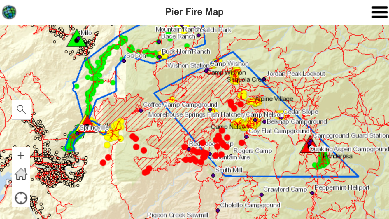
Map Legend:
Green dots are homes.
Blue line is the mandatory evac area.
Green lines are voluntary evac areas.
Squares are cities.
Triangles are road closures.
Red dots represent active fire, which includes controlled backfires that crews are setting to burn fuel ahead of the fire.


Pingback: Pier Fire Update, 8:20am, 9/5/17. 20,529 Acres Burned. | Ponderosa, Ca