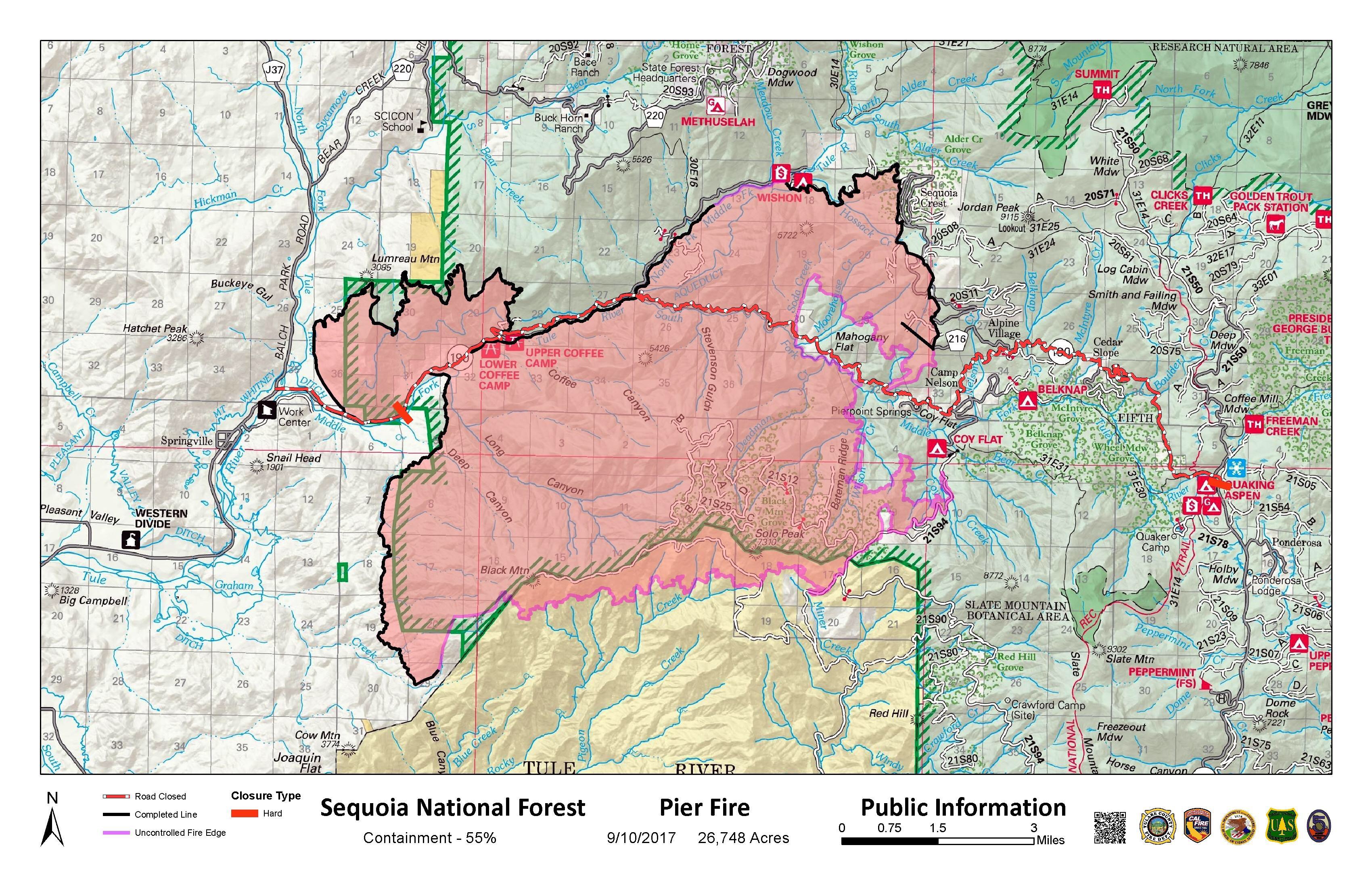
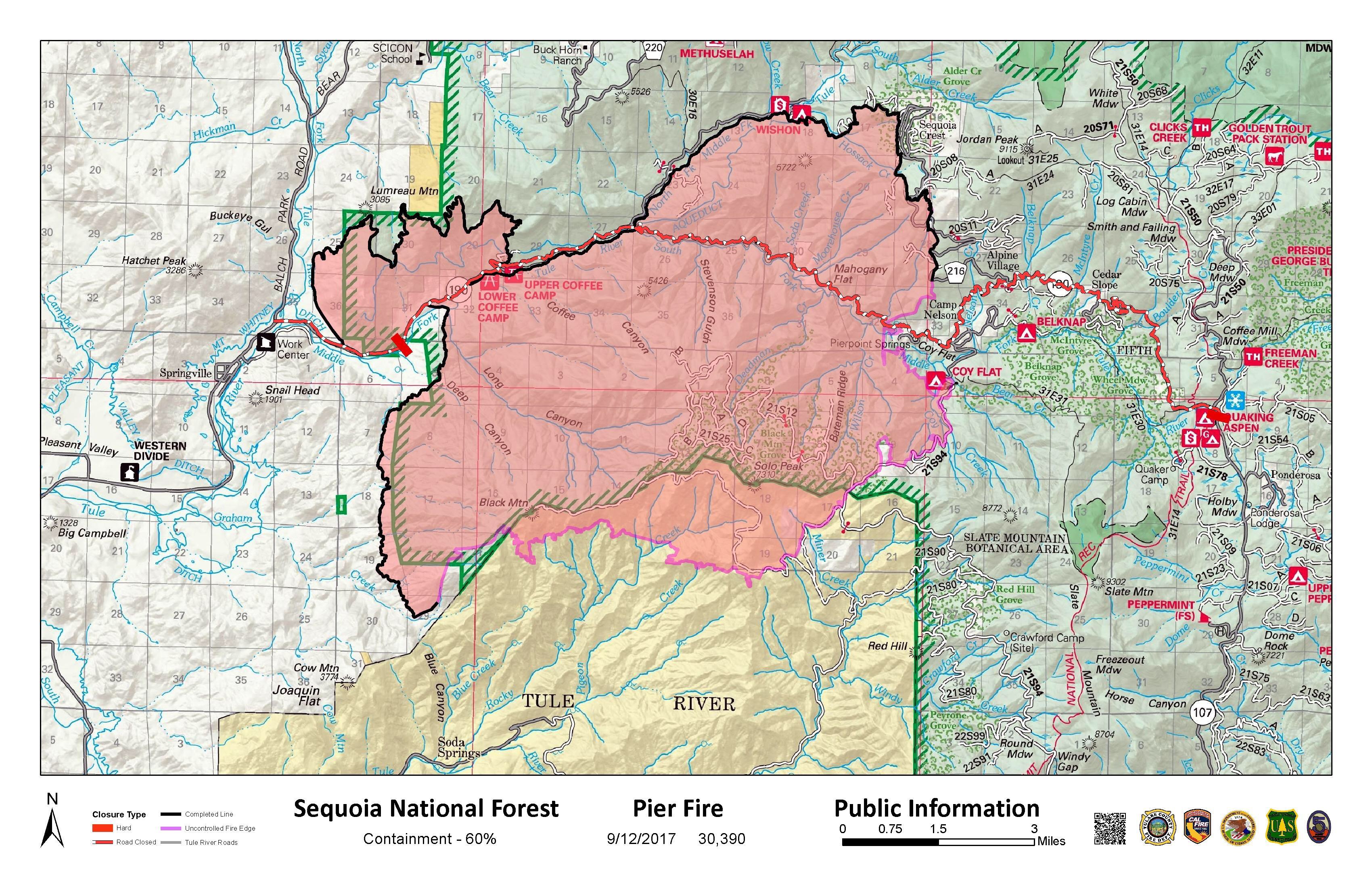
Pier Fire Update, 10am, 9/12/17: 30,390 acres, still 60% contained 


Size: 30,390 acres

Fire Start: August 29, 2017

Containment: 60 percent

Location: Highway 190, east of Springville

Total Personnel: 1,650

Cause: Human caused, under investigation

Resources: Crews 34, Helicopters 8, Engines 123, Dozers 18, Water Tenders 15
Fire Summary: Firefighters continued to make good progress yesterday and into the evening. Fire suppression repair continues along dozer lines on the northern perimeter of the fire. Crews continued to mop-up and patrol fireline on the eastern edge near Camp Nelson. There was a small spot fire—approximately 6 acres—near Pierpoint Springs on the south side of Highway 190. The spot fire was contained using helicopters and hand crews. The spot will be monitored and mopped-up today to ensure it remains contained.
Firefighters will continue to patrol and mop-up containment line along Forest Road 21S94 between Coy Flat Campground and Rogers Camp. On the eastern perimeter of the fire there may be increased smoke due to interior pockets of vegetation burning.
Firing operations will continue today along the 2¼ Road south toward Pine Flat Road on the Tule River Indian Reservation. Firefighters will also be conducting a firing operation along Cow Mountain Road. Smoke and fire will likely be visible within containment lines as interior pockets of vegetation continue to burn. The rain that fell on the fire last night was concentrated primarily on the eastern edge of the fire, and didn’t hamper any burning operations on the southern edge.
Later this morning, be sure to watch the video of Operations Chief Keith Gurrola describe the strategy for continuing firing operations on the Tule River Indian Reservation on the SQF facebook page.

Weather: A low pressure system will move northward today along the coast and then move inland across Central California on Wednesday. A south to southwest flow aloft will allow for one more day of a thunderstorm threat however the greatest threat will remain east of the fire on Tuesday. Temperatures will be 85 to 90 degrees below 3,000 feet, relative humidity will range from 30 to 35 %. Winds will be out of the southeast from 3-6 mph.
Evacuations: Tulare County has two levels of evacuations: voluntary and mandatory. There are currently no voluntary evacuations. Mandatory evacuations are issued when the fire poses an imminent threat to life and property. The following communities are under mandatory evacuation: Sequoia Crest, Mountain Aire, Rogers Camp, Pierpoint Springs, Cedar Slope, Camp Nelson, Doyle Springs, Alpine Village and Wishon.

Area Closures: Sequoia National Forest trails, roads, and lands around the Pier Fire are closed (Closure Order No. 0513-17-34, https://inciweb.nwcg.gov/incident/article/5548/39662/. CAL FIRE has closed Mountain Home State Forest, and Tulare County has closed Balch Park. All areas are closed until the fire is brought under control. Suppression repair work will take additional time after the fire is contained; recreationists should plan ahead.

Hard Road Closures: The following roads are closed to all traffic:

Cow Mountain Road at its intersection with Rio Vista Road.

Highway 190 east of Springville is closed at Upper Rio Vista Road to eastbound traffic.

Highway 190 north of Ponderosa is closed at Forest Road 21S50 to westbound traffic.
Smoke: Today’s weather will be characterized by instability in the atmosphere providing good dispersion conditions. Smoke from today’s planned aerial ignitions is expected to loft high and move north. Bishop may see impacts this afternoon with possible moderate conditions through tonight. Communities along western foothills should generally see clearing this evening.

Daily updated information for the levels of smoke in communities affected by the Pier Fire; http://wildlandfiresmoke.net/outlooks/2017/Pier#Main

People with respiratory conditions, young children, and elderly people may be susceptible to adverse effects. Air District officials urge residents to follow their doctor’s advice. For more information, see https://www.cdc.gov/features/wildfires/index.html or http://valleyair.org/wildfires.htm
Basic Information

Current as of 9/12/2017, 7:55:02 AM

Incident Type Wildfire

Cause Under Investigation

Date of Origin Tuesday August 29th, 2017 approx. 02:30 AM

Location Highway 190 at Wishon Road 7 miles East of Springville

Incident Commander Mike Minton, CIIMT5 Jeff McLaughlin (TC), Derek Staberg (CalFire TUU)

Current Situation

Total Personnel 1,650

Size 30,390 Acres

Percent of Perimeter Contained 60%

Estimated Containment Date Wednesday September 20th, 2017 approx. 12:00 AM

Fuels Involved 

Dormant Brush, Hardwood slash, timber, including areas affected by tree mortality. Fire is located in a heavy timber mortality area. The southern portion of the fire is burning in a location with little to no recorded fire history.

Outlook

Planned Actions 

Provide structure protection for threatened communities and infrastructure. Construct direct and indirect containment line where feasible. Plan and construct contingency line.

Projected Incident Activity 

A full suppression strategy is to be implemented on the Pier Fire. Values at risk associated with the incident include human safety, private property, and associated improvements, electrical power infrastructure, Giant Sequoia groves, and cultural values. Minimize acres burned on privately owned and tribal lands. Apply tactics on public lands that offer the highest probability of success.
Inciweb 
Posted in fire, Fire Brigade, ponderosa | Tagged , , , , , , , , , , , | Leave a comment

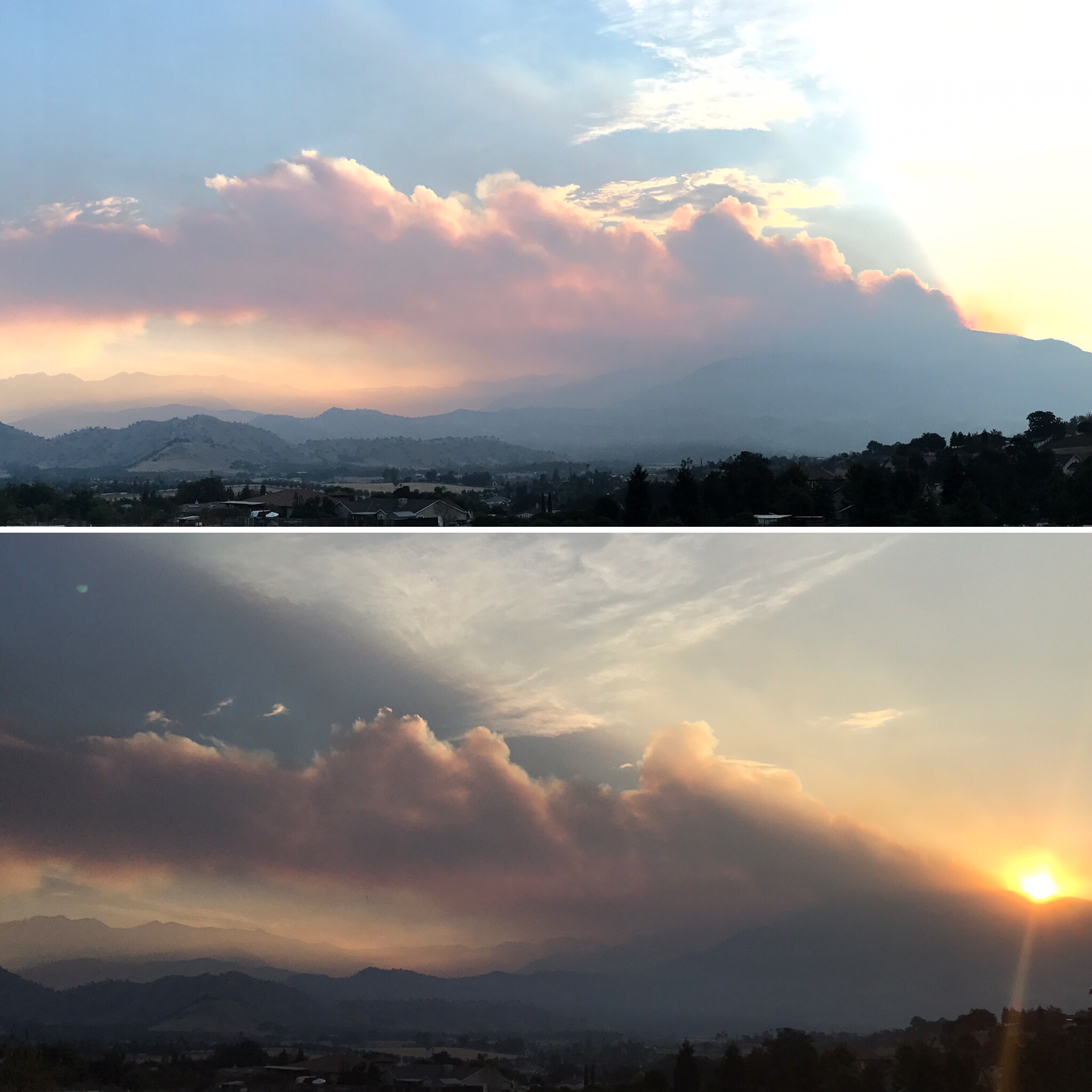
Pier Fire Sunrise Over Black Mountain, 9/11/17

​

​

Posted in fire, ponderosa | Tagged , , , , , , , , , , , , | Leave a comment

Pier Fire Update, 6:30pm, 9/10/17: 60% containment 

Updates will only be once a day now. Seems like things are getting under control!  Fabulous.  Thank you to all who have helped protect all of our mountain communities. 

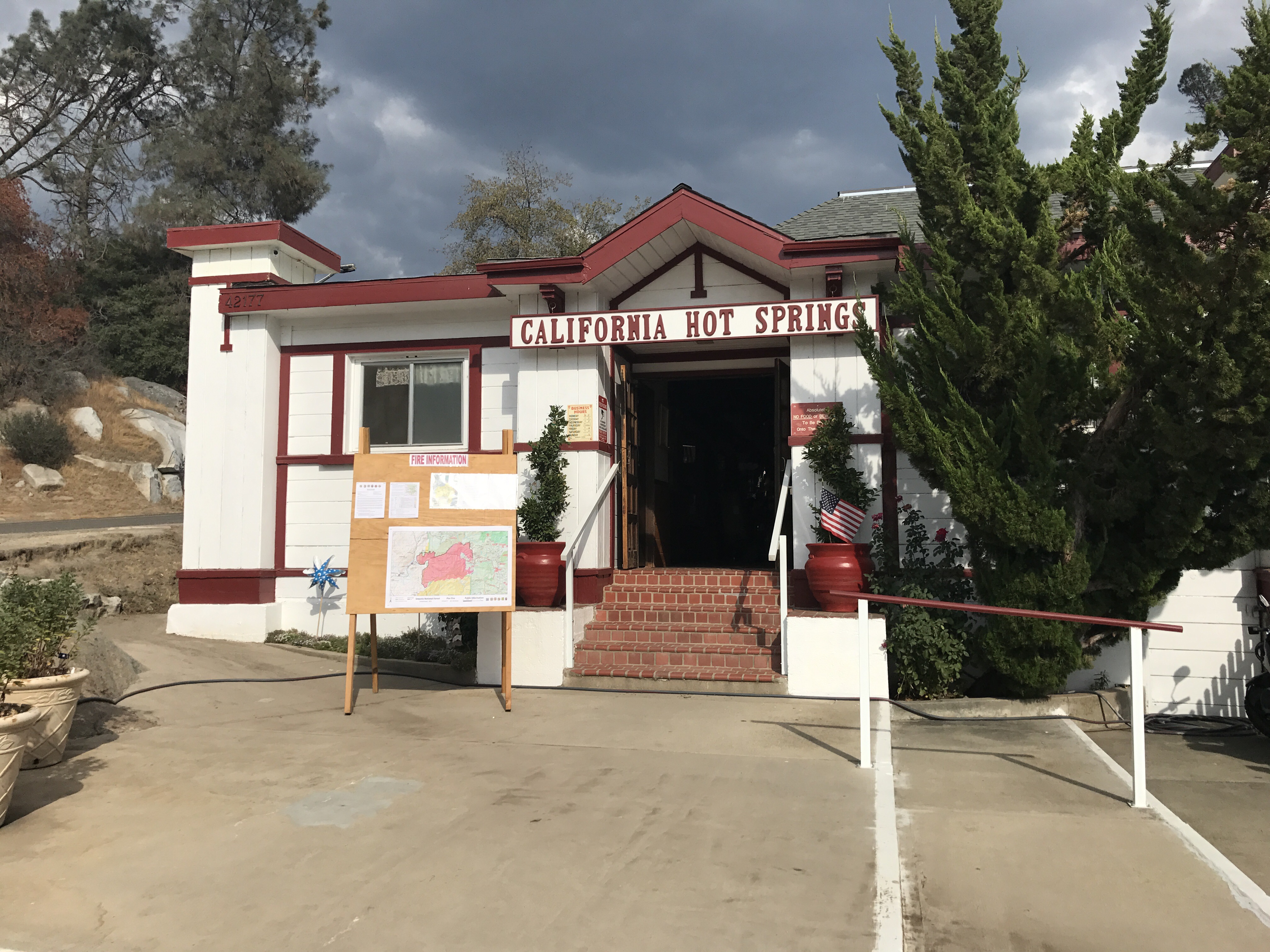
No new map this evening. However here’s a photo of the Update board at California Hot Springs today. Very appreciative of all the great communication we have had! 

Size: 27,290 acres

Fire Start: August 29, 2017

Containment: 60 percent

Location: Highway 190, east of Springville

Total Personnel: 1,780

Cause: Human caused, under investigation

Resources: Crews 35, Helicopters 8, Engines 137, Dozers 22, Water Tenders 18
Announcement: Starting today, barring any significant change in fire activity, there will be a single fire update provided each morning. Please call the fire information line for the most current information

Fire Summary: Today firefighters continued to make good progress. Firefighters mopped up and patrolled areas on the east and northern edge of the fire. The areas near Sequoia Crest were patrolled and monitored for hot spots. Firefighters will continue firing operations from the northeast boundary of the Tule River Indian Reservation southwest to the 2 1/4 Road toward the Pine Flat area.
Firefighters will continue to hold and secure the fireline along the 21S94 Rd. from Roger’s Camp to Coy Flat Campground. Firing operations will also continue north along hand and dozer lines toward Highway 190 west of Pierpoint Springs. These firing operations will bring increased smoke into the general area in and around the fire’s perimeter. Approximately 1,400 firefighters are working in the field, directly suppressing the fire, protecting structures, and establishing containment.
Last night’s public meeting was livestreamed on Facebook, watch the meeting on TC Facebook filmed by Tulare County Fire Department.

Watch a video on the SQF facebook page of Operations Chief Keith Gurrola as he describes the strategy for continuing firing operations near Camp Nelson and on the Tule River Indian Reservation.
Evacuations: Tulare County has two levels of evacuations: voluntary and mandatory. There are currently no voluntary evacuations. Mandatory evacuations are issued when the fire poses an imminent threat to life and property. The following communities are under mandatory evacuation: Sequoia Crest, Mountain Aire, Rogers Camp, Pierpoint Springs, Cedar Slope, Camp Nelson, Doyle Springs, Alpine Village and Wishon.

Area Closures: Sequoia National Forest trails, roads, and lands around the Pier Fire are closed (Closure Order No. 0513-17-34, https://inciweb.nwcg.gov/incident/article/5548/39662/. CAL FIRE has closed Mountain Home State Forest, and Tulare County has closed Balch Park. All areas are closed until the fire is brought under control. Suppression repair work will take additional time after the fire is contained; recreationists should plan ahead.

Hard Road Closures: The following roads are closed to all traffic:

Cow Mountain Road at its intersection with Rio Vista Road.

Highway 190 east of Springville is closed at Upper Rio Vista Road to eastbound traffic.

Highway 190 north of Ponderosa is closed at Forest Road 21S50 to westbound traffic.
Smoke: Information for the levels of smoke in communities affected by the Pier Fire; http://wildlandfiresmoke.net/outlooks/2017/Pier#Main

People with respiratory conditions, young children, and elderly people may be susceptible to adverse effects. Air District officials urge residents to follow their doctor’s advice. For more information, see https://www.cdc.gov/features/wildfires/index.html or http://valleyair.org/wildfires.htm

Basic Information

Current as of 9/10/2017, 6:07:50 PM

Incident Type Wildfire

Cause Under Investigation

Date of Origin Tuesday August 29th, 2017 approx. 02:30 AM

Location Highway 190 at Wishon Road 7 miles East of Springville

Incident Commander Mike Minton, CIIMT5 Jeff McLaughlin (TC), Derek Staberg (CalFire TUU)

Current Situation

Total Personnel 1,819

Size 27,290 Acres

Percent of Perimeter Contained 60%

Estimated Containment Date Wednesday September 20th, 2017 approx. 12:00 AM

Fuels Involved 

Dormant Brush, Hardwood slash, timber, including areas affected by tree mortality. Fire is located in a heavy timber mortality area. The southern portion of the fire is burning in a location with little to no recorded fire history.

Significant Events 

Warm temperatures and a building monsoonal influence supported active surface fire in high elevations above the morning inversion. Creeping, smoldering and backing were seen in interior islands of unburned fuel away from the current perimeter. Fire weakened trees continued to provide a strong mechanism for rolling and spotting.

Outlook

Planned Actions 

Provide structure protection for threatened communities and infrastructure. Construct direct and indirect containment line where feasible. Plan and construct contingency line.

Projected Incident Activity 

A full suppression strategy is to be implemented on the Pier Fire. Values at risk associated with the incident include human safety, private property, and associated improvements, electrical power infrastructure, Giant Sequoia groves, and cultural values. Minimize acres burned on privately owned and tribal lands. Apply tactics on public lands that offer the highest probability of success.

Remarks 

The voluntary evacuation order for the Upper Rio Vista Area was rescinded yesterday.

Current Weather

Weather Concerns 

Partly cloudy with a 20% chance of thunderstorms. Lows 70-75 lower elevations and 58-65 higher terrain. Maximum humidity 45-50 lower elevations and 55-60 higher terrain. Winds downslope 3-7 mph. with gusts to around 15 mph in larger drainages. Ridge winds east 10-15 mph

Inciweb

Posted in fire, Fire Brigade, ponderosa | Tagged , , , , , , , , , | Leave a comment

Pier Fire Update, 8am, 9/10/17: More containment, minimal growth. 

Great Sunday News! 
Size: 26,748 acres

Fire Start: August 29, 2017

Containment: 55 percent

Location: Highway 190, east of Springville

Total Personnel: 1,819

Cause: Human caused, under investigation

Resources: Crews 35, Helicopters 8, Engines 138, Dozers 22, Water Tenders 14
Yesterdays public meeting was livestreamed on Facebook, watch the meeting on TC Facebook filmed by Tulare County Fire Department. An evening update will no longer be distributed, expect a morning update by 9 a.m.
Fire Summary: Last night, firefighters patrolled and mopped up along the containment lines on the western and northern portions of the fire. Firing operations will continue today from Rogers Camp towards Coy Flat to widen the perimeter line to keep fire from moving past it. Additional reinforcement and firing will continue today in those areas. 

Firefighters will continue to prepare and improve line on the south edge of the fire on the Tule River Indian Reservation in preparation for a firing operation. Some ignition began in the Blue Canyon area. When conditions are right, fire will be carried across to tie in with the perimeter lines near Solo Peak and Rogers Camp.
Fire suppression repair (impacts directly caused by firefighting efforts or activity) continues on the western and northern portions of the fire. This work will be done along those contained lines at the same time as firing and suppression efforts occur along the east and south perimeters. 
Watch a video on the SQF facebook page of Incident Commander Mike Minton, or Operations Chief Keith Gurrola as they describe the strategy for continuing firing operations near Camp Nelson and on the Tule River Indian Reservation.

Evacuations: Tulare County has two levels of evacuations: voluntary and mandatory. Mandatory evacuations are issued when the fire poses an imminent threat to life and property. There are currently no voluntary evacuations. 

Mandatory: Sequoia Crest, Mountain Aire, Rogers Camp, Pierpoint Springs, Cedar Slope, Camp Nelson, Doyle Springs, Alpine Village, Wishon

Evacuation Center: As of 8 pm Friday evening the Red Cross shelter in Porterville was closed, there were no longer any evacuees that were sheltered at that location. They are equipped to reopen if needed. For additional assistance, please contact Red Cross at 661-324-6427 ext. 6510.
Area Closures: Sequoia National Forest trails, roads, and lands around the Pier Fire are closed (Closure Order No. 0513-17-34, https://inciweb.nwcg.gov/incident/article/5548/39662/. CAL FIRE has closed Mountain Home State Forest, and Tulare County has closed Balch Park. All areas are closed until the fire is brought under control. Suppression repair work will take additional time after the fire is contained; recreationists should plan ahead.
Hard Road Closures: The following roads are closed to all traffic:

Cow Mountain Road at its intersection with Rio Vista Road.

Highway 190 east of Springville is closed at Upper Rio Vista Road to eastbound traffic.

Highway 190 north of Ponderosa is closed at Forest Road 21S50 to westbound traffic.
Smoke: Information for the levels of smoke in communities affected by the Pier Fire; http://wildlandfiresmoke.net/outlooks/2017/Pier#Main

People with respiratory conditions, young children, and elderly people may be susceptible to adverse effects. Air District officials urge residents to follow their doctor’s advice. For more information, see https://www.cdc.gov/features/wildfires/index.html or http://valleyair.org/wildfires.htm
Basic Information

Current as of 9/10/2017, 6:55:31 AM

Incident Type Wildfire

Cause Under Investigation

Date of Origin Tuesday August 29th, 2017 approx. 02:30 AM

Location Highway 190 at Wishon Road 7 miles East of Springville

Incident Commander Mike Minton, CIIMT5 Jeff McLaughlin (TC), Derek Staberg (CalFire TUU)

Current Situation

Total Personnel 1,819

Size 26,748 Acres

Percent of Perimeter Contained 55%

Estimated Containment Date Wednesday September 20th, 2017 approx. 12:00 AM

Fuels Involved 

Dormant Brush, Hardwood slash, timber, including areas affected by tree mortality. Fire is located in a heavy timber mortality area. The southern portion of the fire is burning in a location with little to no recorded fire history.

Significant Events 

Overnight, active fire behavior was seen in the lower elevations well away from control lines. Interior islands were creeping, backing, and smoldering. Heavy fuels over the higher terrain continued to burn actively with low and moderate intensity surface fire as well as occasional tree torching. Steep slopes produced rollout and limited spotting in recently burned areas.

Outlook

Planned Actions 

Provide structure protection for threatened communities and infrastructure. Construct direct and indirect containment line where feasible. Plan and construct contingency line.

Projected Incident Activity 

A full suppression strategy is to be implemented on the Pier Fire. Values at risk associated with the incident include human safety, private property, and associated improvements, electrical power infrastructure, Giant Sequoia groves, and cultural values. Minimize acres burned on privately owned and tribal lands. Apply tactics on public lands that offer the highest probability of success.

Remarks 

The voluntary evacuation order for the Upper Rio Vista Area was rescinded yesterday.

Current Weather

Weather Concerns 

Partly cloudy with a 20% chance of thunderstorms. Lows 63-68 lower elevations and 55-60 higher terrain. Maximum humidity 35-40 lower elevations and 45-50 higher terrain. Winds downslope 2-6 mph. Ridge winds southeast to east 6-10 mph.

Inciweb

Posted in fire, Fire Brigade, ponderosa | Tagged , , , , , , , , | Leave a comment