It appears the famous flume above Springville has burned, along with a lot of So Cal Edison infrastructure.
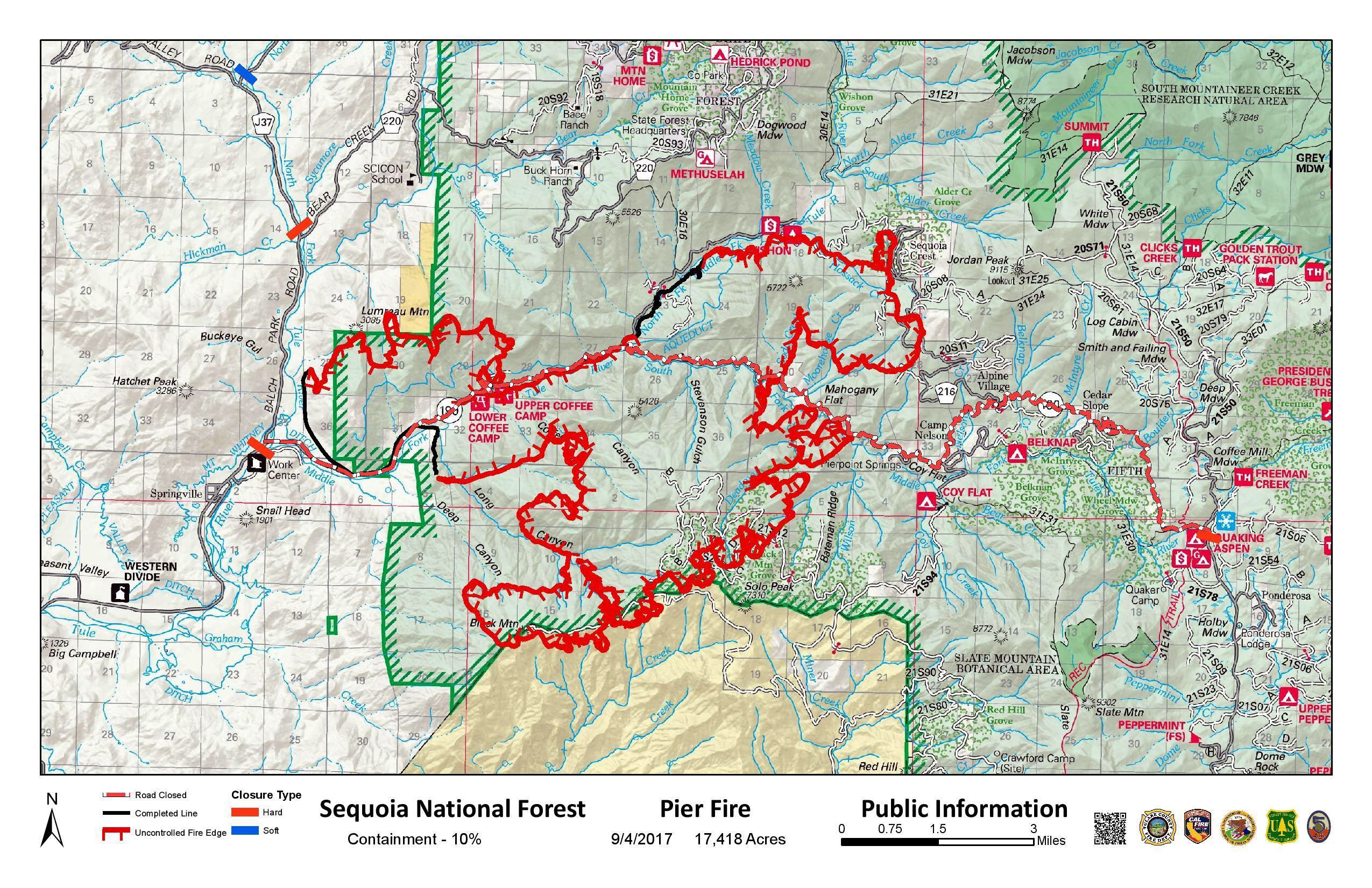
Size: 17,980
Percent Contained: 10%
Fire Start: August 29, 2017
Location: Highway 190, east of Springville
Cause: Human caused, under investigation
Total Personnel: 1,416
Injuries: 3 minor injuries
Resources: 30 Crews, 6 Helicopters, 113 Engines, 21 Dozers, 13 Water Tenders
Special Announcement:
Residents affected by the Pier Fire are encouraged to attend a follow-up community meeting on Tuesday, September 5th at Porterville College located at 100 E. College Ave. in Porterville. The meeting is set to begin at 6:00 p.m. and will take place in the Student Conference Center.
Fire Summary: Light rain slowed the fires advance last night and early this morning, but when the sun came out this afternoon, the fire became active again. On the west side of the fire near Balch Park Road, good progress was made in lighter fuels. Containment lines were built along the edge of the fire where it was less active, and those efforts will continue overnight.
Another spot fire along Redwood Drive around 10 a.m. today will require additional efforts. The perimeter of the Fire between Rogers Camp and Hwy 190 became active this afternoon, air tankers dropped retardant along Bateman Ridge and many resources will be working in there overnight to slow the spread.
Evacuations: Tulare County has two levels of evacuations: mandatory and voluntary. Mandatory evacuations are issued when the fire poses an imminent threat to life and property. Voluntary evacuations means residents should either evacuate or be prepared to do so should fire conditions worsen.
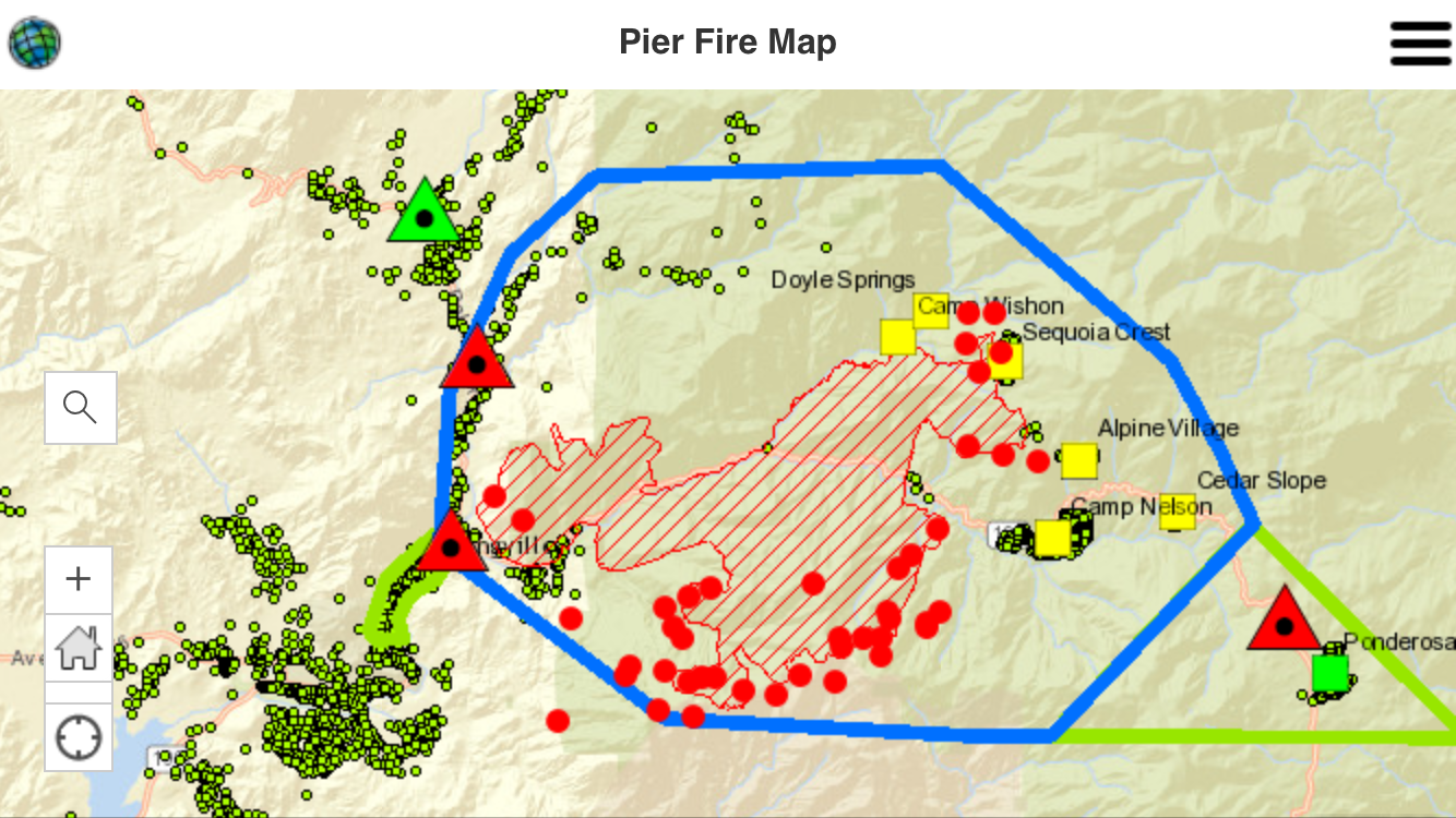
Mandatory: Residences along Balch Park Road (County J37) north of Highway 190 to Bear Creek Road, Bear Creek Road (County 220) east of Balch Park Road, Scicon, Mountain Home Conservation Camp, Upper Rio Vista, Cow Mountain (Springville area), Sequoia Crest, Mountain Aire, Rogers Camp, Pierpoint Springs, Cedar Slope, Camp Nelson, Doyle Springs, Alpine Village, Wishon
Voluntary: Springville, Ponderosa
Evacuation Center: Porterville College Student Center, 100 E. College Ave., Porterville. Call 661-324-6427 (weekdays) or 800-REDCROSS (1-800-733-2767) Provide food, shelter, arrange for animal care, and other basic needs for evacuees.
Road Closures:
Closed to all traffic: Highway 190, east of Springville where it intersects with Balch Park Road. Western Divide Highway/HWY 190, west of Ponderosa, west of and including the North Road (FR 21S50) Balch Park Road is closed from the intersection of HWY 190 to Bear Creek Road.
Open only to residents (with proof of residency) Balch Park Road (J37) from Yokohl Valley Road to Bear Creek Road.
Area Closures: Sequoia National Forest closure includes trails, roads, and lands around the Pier Fire: Closure Order No. 0513-17-34 https://inciweb.nwcg.gov/incident/article/5548/39662/ CALFIRE has closed Mountain Home State Forest, and Tulare County has closed Balch Park. All areas are closed until the fire is brought under control. Please keep in mind, suppression repair work will take additional time after the fire is contained, recreationists should plan ahead.
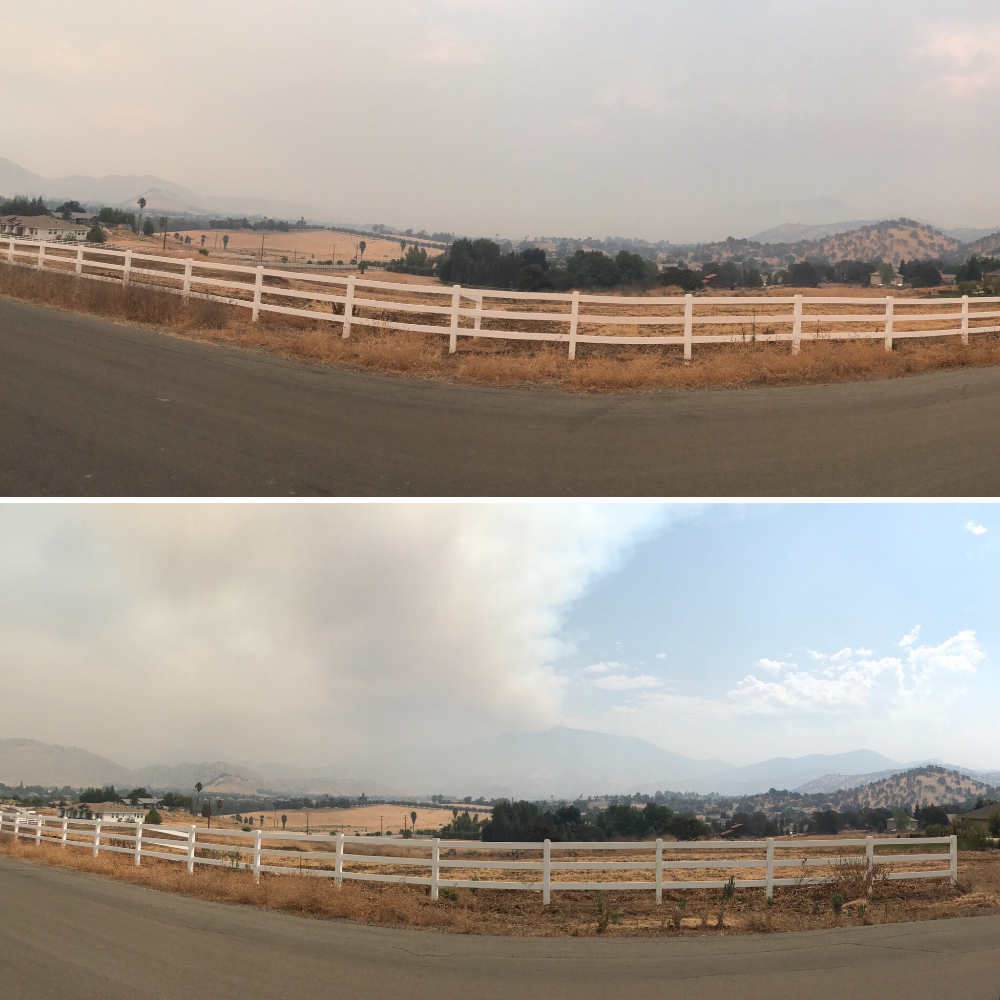
Smoke: Information for the levels of smoke in communities affected by the Pier Fire; http://wildlandfiresmoke.net/outlooks/2017/Pier#Main
People with respiratory conditions, young children, and elderly people may be susceptible to adverse effects. Air District officials urge residents to follow their doctor’s advice. For more information, see https://www.cdc.gov/features/wildfires/index.html or http://valleyair.org/wildfires.htm
Basic Information
Current as of 9/4/2017, 7:40:15 PM
Incident Type Wildfire
Cause Under Investigation
Date of Origin Tuesday August 29th, 2017 approx. 02:30 AM
Location Highway 190 at Wishon Road 7 miles East of Springville
Incident Commander Mike Minton, CIIMT5 Jeff McLaughlin (TC), Derek Staberg (CalFire TUU)
Current Situation
Total Personnel 1,416
Size 17,980 Acres
Percent of Perimeter Contained 10%
Fuels Involved
Dormant Brush, Hardwood slash, timber, including areas affected by tree mortality. Fire is located in a heavy timber mortality area. The southern portion of the fire is burning in a location with little to no recorded fire history.
Significant Events
Arriving instability brought cooler and more humid conditions. As a result, diminished but still active surface fire was observed in all fuel types. Isolated torching and medium range spotting were confined to areas of favorable wind and slope alignment.
Outlook
Planned Actions
Provide structure protection for threatened communities and infrastructure. Construct direct and indirect containment line where feasible. Plan and construct contingency line.
Projected Incident Activity
A full suppression strategy is to be implemented on the Pier Fire. Values at risk associated with the incident include human safety, private property, and associated improvements, electrical power infrastructure, Giant Sequoia groves, and cultural values. Minimize acres burned on privately owned and tribal lands. Apply tactics on public lands that offer the highest probability of success.
Remarks
A So Cal Edison water flume, with an estimated replacement cost of 3 to 5 million dollars, was reported as destroyed today. Previously reported destroyed So Cal Edison infrastructure has been valued at $1,000,000
Current Weather
Weather Concerns
Partly cloudy with a 20% chance of thunderstorms through 9 pm. Lows 70-75 below 3000 feet. 60-65 higher elevations. Maximum relative humidity 35-40% below 3000 feet and 45-50% higher elevations. Winds downslope 2-6 mph with gusts to around 15 mph.