
Latest update here. Info below is old.
Size: 17,418 acres (appears to have not grown or not updated?)
Percent Contained: 5%
Location: Highway 190, east of Springville
Total Personnel: 1,378
Cause: Human caused, under investigation
Resources: 30 crews, 6 helicopters, 109 engines
21 dozers, 13 water tenders
Fire Summary: Fire continued to burn actively through the day, primarily on the south side of the fire. On the east side of the fire crews continued to contain a thirty-acre spot assisted by retardant drops and helicopter bucket drops. Crews continued to construct and improve dozerline and handline in the Balch Park area to protect structures near the northwest side of the fire.
Weather- A strong high-pressure system over the Great Basin combined with a low pressure off the southwest California coast will keep a persistent southeast moist flow moving over the fire area tonight through Tuesday. Thunderstorm chances will continue over the next several days mainly during the afternoon and evening hours. Temperatures will trend lower, especially Monday with a slow warming trend through the upcoming week. Relative humidity will show little day to day change.
Damaged or Destroyed Structures: Buildings and equipment belonging to Southern California Edison were determined to have been destroyed. These include a valve house above the Tule Power house, six distribution poles and associated equipment. Loss of this equipment affected both SoCal Edison and PG& E power transmission infrastructure
Injuries: 2 reportable injuries have occurred thus far on this incident.
Smoke: Information for the levels of smoke in communities affected by the Pier Fire;
https://californiasmokeinfo.blogspot.com/
People with respiratory conditions, young children, and elderly people may be susceptible to adverse effects. Air District officials urge residents to follow their doctor’s advice. For more information, see https://www.cdc.gov/features/wildfires/index.html or http://valleyair.org/wildfires.htm.
Evacuations: Tulare County has two levels of evacuations: voluntary and mandatory. A voluntary evacuation means residents should either evacuate or be prepared to do so should fire conditions worsen. Mandatory evacuations are issued when the fire poses an imminent threat to life and property.
Mandatory: Residences along Balch Park Road (County J37) north of Highway 190 to Bear Creek Road, Bear Creek Road (County 220) east of Balch Park Road, Scicon, Mountain Home Conservation Camp
Mandatory: Upper Rio Vista, Cow Mountain (Springville area), Sequoia Crest, Mountain Aire, Rogers Camp, Pierpoint Springs, Cedar Slope, Camp Nelson, Doyle Springs, Alpine Village, Wishon
Voluntary: Springville, Ponderosa
Evacuation Center: Porterville College Student Center, 100 E. College Ave., Porterville. Call 661-324-6427 (weekdays) or 800-REDCROSS.
Area Closures: Sequoia National Forest Closure Order No. 0513-17-34 Forest trails, roads, and lands around the Pier Fire are closed https://inciweb.nwcg.gov/incident/article/5548/39662/
CAL FIRE has closed Mountain Home State Forest and Tulare County has closed Balch Park.
All closed areas will remain closed until the fire is brought under control. Keep in mind that suppression repair work will need to be completed prior to areas being re-opened to recreational visitors.
Hard Road Closures: The following roads are closed to all traffic:
Highway 190 east of Springville is closed south of Balch Park Road.
Highway 190 north of Ponderosa is closed at Forest Road 21S50.
Balch Park Road is closed at Bear Creek Road.
Soft Road Closures: The following roads are open only to residents with a photo ID:
Balch Park Road (County Road J37) at its junction with Yokohl Valley Road.
https://inciweb.nwcg.gov/incident/5548/
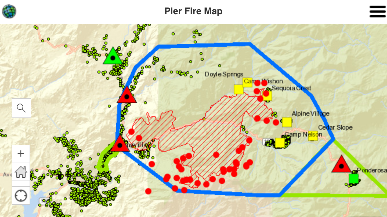
Green dots are homes.
Blue line is the mandatory evac area.
Green lines are voluntary evac areas.
Squares are cities.
Triangles are road closures.
Red dots represent active fire, which includes controlled backfires that crews are setting to burn fuel ahead of the fire.


Pingback: Pier Fire Current Map and Update – 8am, 9/3/17 | Ponderosa, Ca