
For the latest update please click here.
The info below is outdated. 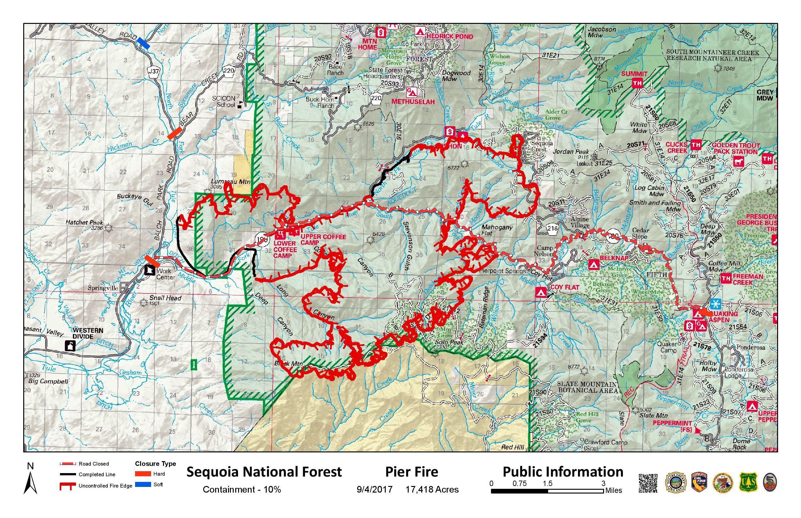
Size: 17,418
Fire Start: August 29, 2017
Percent Contained: 10%
Location: Highway 190, east of Springville
Total Personnel: 1,378
Cause: Human caused, under investigation
Resources: 30 crews, 6 helicopters, 109 engines,
21 dozers, 13 water tenders
Fire Summary: Minimal growth was seen on the fire last night. Rain affected some parts of the fire, while other portions received none. Burning operations on the west side of the fire were halted, and the cool weather is giving crews an opportunity to go direct in the Balch Park road area starting this morning. Firefighters continue to secure spot fires in the Sequoia Crest area and improve fireline construction down towards highway 190. Dozers have been reallocated from areas around the fire to facilitate completion of line from Rogers Camp down to Camp Nelson and improve lines from Rogers Camp onto the Tule River Indian Reservation. Firefighters will continue to look for favorable conditions to complete planned burning operations throughout the day. Power companies will also continue to replace power poles and repair infrastructure damaged by the fire.
Weather: Higher relative humidity and lower temperatures are forecast for today as the movement of monsoon moisture comes into the area. This will be temporary as an expected regional high pressure will begin to develop over the next several days.
Injuries: 3 minor injuries
Smoke: Information for the levels of smoke in communities affected by the Pier Fire;
https://californiasmokeinfo.blogspot.com/
People with respiratory conditions, young children, and elderly people may be susceptible to adverse effects. Air District officials urge residents to follow their doctor’s advice. For more information, see https://www.cdc.gov/features/wildfires/index.html or http://valleyair.org/wildfires.htm.
Evacuations: Tulare County has two levels of evacuations: voluntary and mandatory. A voluntary evacuation means residents should either evacuate or be prepared to do so should fire conditions worsen. Mandatory evacuations are issued when the fire poses an imminent threat to life and property.
Mandatory: Residences along Balch Park Road (County J37) north of Highway 190 to Bear Creek Road, Bear Creek Road (County 220) east of Balch Park Road, Scicon, Mountain Home Conservation Camp
Mandatory: Upper Rio Vista, Cow Mountain (Springville area), Sequoia Crest, Mountain Aire, Rogers Camp, Pierpoint Springs, Cedar Slope, Camp Nelson, Doyle Springs, Alpine Village, Wishon
Voluntary: Springville, Ponderosa
Evacuation Center: Porterville College Student Center, 100 E. College Ave., Porterville. Call 661-324-6427 (weekdays) or 800-REDCROSS.
Area Closures: Today, the Sequoia National Forest issued Closure Order No. 0513-17-34 (https://inciweb.nwcg.gov/incident/article/5548/39662/). Forest trails, roads, and lands around the Pier Fire are closed until the fire is declared out. CAL FIRE has closed Mountain Home State Forest, and Tulare County has closed Balch Park. Both are closed until the fire is brought under control.
Hard Road Closures: The following roads are closed to all traffic:
Highway 190 east of Springville is closed south of Balch Park Road.
Highway 190 north of Ponderosa is closed at Forest Road 21S50.
Balch Park Road is closed at Bear Creek Road.
Soft Road Closures: The following roads are open only to residents with a photo ID:
Balch Park Road (County Road J37) at its junction with Yokhol Valley Road.


Pingback: Pier Fire Update, 9:30pm, 9/3/17…Some Containment! | Ponderosa, Ca