Ponderosa appears to still be in the clear as of now. Upper Springville is of concern.
INCIDENT UPDATED 735am, September 1, 2017.
Size: Approximately 6,794 acres
Fire Start: August 29, 2017
Percent Contained: 0 percent
Location: Highway 190, east of Springville
Total Personnel: 1,132
Cause: Human caused, under investigation
Resources: 17 hand crews, 5 helicopters, 112 engines, 11 dozers, 10 water tenders
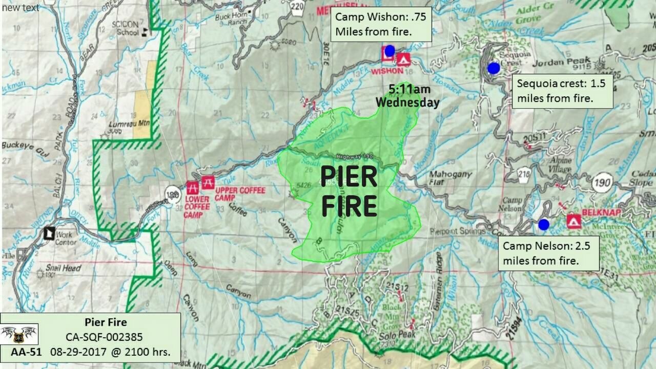
Fire Summary: Today the fire continued to burn intensely in areas of the southwest Tule River drainage. Still, no major growth occurred on any portion of the fire. Most growth occurred on the fire’s west side in the Tule River drainage west of the Wishon drainage. On the northwest side, the fire continued to spread downslope toward the Wishon Road but did not spot across the road. On the northeast side of the fire, near the community of Sequoia Crest, crews protected structures and constructed contingency firelines away from the fire’s edge in anticipation of the fire advancing northeast. On the east side, near Camp Nelson exhibited minimal fire growth. The fire moved primarily west and south toward the Tule River Indian Reservation.
At this evening’s operational briefing, fire managers clearly identified the objective: fully suppress the fire by constructing mainly indirect (i.e., away from the fire’s edge) fireline. The steep, rocky terrain, thick in places with vegetation that has not experienced fire in nearly 100 years, poses a threat to firefighters attempting to construct fireline directly at the fire’s edge. Priorities are to protect threatened residences, to keep the fire south of Mountain Home State Forest, and to protect the Giant-Sequoia groves. Tonight, crews will be positioned to protect structures and values at risk on all sides of the fire.
Weather and Fire Behavior: Tonight will be moderate with temperatures in the 70s. Humidities will recover slightly to 42 percent.Winds will shift downslope with night time cooling 2 to 6 miles per hour downslope with gust to 10 miles per hour. The Incident Meteorologist is concerned with the movement of thunderstorms both to the north and south moving toward each other that may cause erratic winds over the fire area tonight.
Evacuations: Tulare County has two levels of evacuations: voluntary and mandatory. A voluntary evacuation means residents should either evacuate or be prepared to do so should conditions worsen. All residents evacuating are advised to use eastbound Highway 190 to Mountain Road 107 (Western Divide Highway).
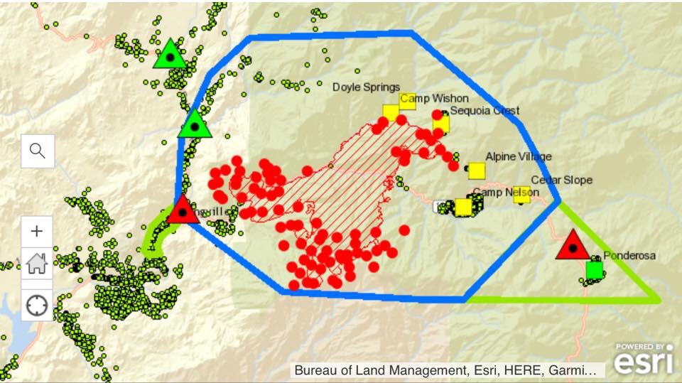
Mandatory: Pierpoint Springs, Wishon, Doyle Springs, Alpine, Sequoia Crest, Cedar Slope, Mountain Aire (Rogers Camp), and Camp Nelson
Voluntary: Ponderosa
Evacuation Center: Porterville College at the Student Conference Center, 100 E. College Ave., Porterville. Call 1-800 REDCROSS.
Area Closures: Mountain Home Demonstration State Forest (CALFIRE) and Balch Park (Tulare County) are closed until the fire is brought under control.
Road closures:
East of Springville, Highway 190 is closed to eastbound traffic at Balch Park Road.
Mountain Road 107 (Western Divide Highway) is closed to westbound traffic at Fox Road in Ponderosa.
A soft closure, meaning a road is open to residents only, are set at Balch Park Road and Bear Creek Road; and Balch Park Road and Yokhol Valley Road
https://inciweb.nwcg.gov/incident/5548/
Updated incident report as of 8:30am, 8/31/17:
Website: https://inciweb.nwcg.gov/incident/5548/
Size: Approximately 6000 acres
Fire Start: August 30, 2017
Percent Contained: 0 percent
Location: Highway 190, east of Springville
Total Personnel: 668
Cause: Under investigation
Resources: 25 hand crews, 5 aircraft, 65 engines,15 dozers, 6 water tenders
Fire Summary:
The Pier Fire, located in the Tule River Canyon above Springville grew to an estimated 6000 acres today. Continued smoke over the fire has limited visibility, Fire mapping is planned overnight, an updated map and fire size should be provided in the morning update. No structures have been damaged, the fire’s perimeter continues to be a mile or more away from the nearest structure as of this evening.
Air Tankers and helicopters are assigned and will be used as conditions allow to support ground personnel. Hand crews, engines, water tenders, and dozers are working to stop the spread of the fire. Additionally, they are working to reduce fuels in front of the fire, and around structures to assist in mitigating the threat.
The Pier Fire burned both north and south of Highway 190 on the Western Divide Ranger District in the Giant Sequoia National Monument, Sequoia National Forest.
Tulare County Evacuations and Road Status: Tulare County has two levels of evacuations: voluntary and mandatory. A voluntary evacuation means that residents should either evacuate or be prepared to do so should conditions worsen.
A mandatory evacuation order is in place for Pierpoint Springs, Wishon, Doyle Springs, Alpine, Sequoia Crest, Cedar Slope, Mountain Aire (Rogers Camp) and Camp Nelson.
Ponderosa remains under a voluntary evacuation advisory.
All residents evacuating are advised to use east bound Highway 190 to the Western Divide Highway.
Evacuation Center: Porterville College at the Student Conference Center, located at 100 East College Avenue in Porterville. For information call 1-800 REDCROSS
Mountain Home Demonstration State Forest (CALFIRE) and Balch Park (Tulare County) are closed until the fire is brought under control.
Road closures:
Highway 190 is currently closed between Balch Park turn off above Springville and Fox Road along the Western Divide Highway below Ponderosa.
Unified Command:
Incident Commanders Mike Minton, California Interagency Incident Management Team 5 representing the U.S. Forest Service, Jeff McLaughlin representing Tulare County Fire Department, and Zane Santos representing Bureau of Indian Affairs and Tule River Indian Reservation.
Updated incident report at of 7:45pm, 8/30/17:
The Pier Fire, located in the Tule River Canyon above Springville grew to an estimated 6000 acres. No structures have been damaged, the fires perimeter was a mile or more away from the nearest structure as of 6 a.m. this morning. Additional mapping will occur overnight.
Air was limited again today due to smoke lingering in the Tule River Canyon. Air Tankers and helicopters are assigned and will be used as conditions allow to support ground personnel. Engines have been assigned to areas that were evacuated for structure protection. The Pier Fire burned both north and south of Highway 190 on the Western Divide Ranger District in the Giant Sequoia National Monument, Sequoia National Forest.
Highway 190 is currently closed between Balch Park turnoff above Springville, and Fox Road along the Western Divide Highway below Ponderosa. Mountain Home Demonstration State Forest (CALFIRE) and Balch Park (Tulare County) are closed until the fire is brought under control.
The following communities are under a mandatory evacuation order: Pierpoint Springs, Wishon, Doyle Springs, Alpine, Sequoia Crest, Cedar Slope, and Camp Nelson. Ponderosa remains under a voluntary evacuation advisory. All residents who are evacuating are advised to use east bound Highway 190 to the Western Divide Highway.
Evacuation Center: Porterville College at the Student Conference Center, located at 100 East College Avenue in Porterville. For information call 1-800 REDCROSS
U.S. Forest Service, Bureau of Indian Affairs, and Tulare County Fire Department are in unified command at this time. An Incident Command Team has assumed command of the fire as of 6 p.m. The cause of the fire is under investigation. For more information, please call 559-539-2607 ext. 2292 7 a.m. – 8 p.m.
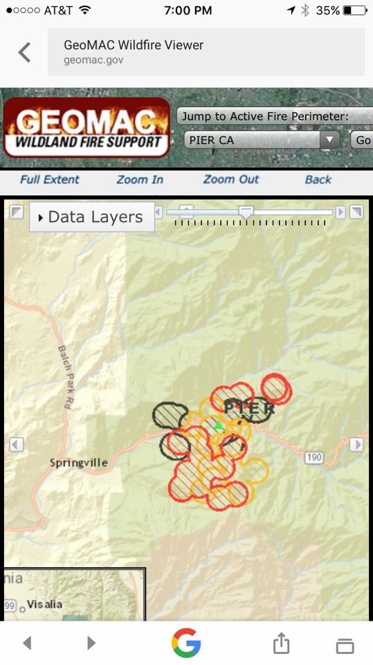
Updated map as of 7pm, 8/30/17

Update as of 7am, 8/30/17 Inciweb
The Pier Fire, located in the Tule River Canyon above Springville grew rapidly overnight to an estimated 4655 acres. No structures have been damaged, the fires perimeter was a mile or more away from the nearest structure as of 6 a.m. this morning.
Most of the growth overnight was south of the highway towards Black Mountain and the Tule River Indian Reservation. The fire is nearing the Black Mountain Grove of giant sequoias near Solo Peak. Access into this part of the fire is extremely difficult with few roads, heavy fuels, and steep slopes.
Air support may be limited again today due to smoke lingering in the Tule River Canyon. Air Tankers and helicopters are assigned and will be used as conditions allow to support ground personnel. Engines have been assigned to areas that were evacuated for structure protection. The Pier Fire burned both north and south of Highway 190 on the Western Divide Ranger District in the Giant Sequoia National Monument, Sequoia National Forest.
Highway 190 is currently closed between Balch Park turnoff above Springville, and Fox Road along the Western Divide Highway below Ponderosa. Mountain Home Demonstration State Forest (CALFIRE) and Balch Park (Tulare County) are closed until the fire is brought under control.
The following communities are under a mandatory evacuation order: Pierpoint Springs, Wishon, Doyle Springs, Alpine, Sequoia Crest, Cedar Slope, and Camp Nelson. Ponderosa remains under a voluntary evacuation advisory. All residents who are evacuating are advised to use east bound Highway 190 to the Western Divide Highway.
Evacuation Center: Porterville College at the Student Conference Center, located at 100 East College Avenue in Porterville. For information call 1-800 REDCROSS
U.S. Forest Service, Bureau of Indian Affairs, and Tulare County Fire Department are in unified command at this time. An Incident Command Team is expected to arrive today and will assume command as of 6 p.m. The cause of the fire is under investigation. For more information, please call 559-539-2607 ext. 2292 7 a.m. – 8 p.m.
Basic Information
Current as of 8/30/2017, 6:57:26 AM
Incident Type Wildfire
Cause Under Investigation
Date of Origin Tuesday August 29th, 2017 approx. 02:30 AM
Location Along Highway 190 near Stairs
Incident Commander Robert Benik (T) Ernie Villa
Current Situation
Total Personnel 1,000
Size 4,655 Acres
Significant Events
Evacuations in effect
Outlook
Remarks
Highway 190 closed above Springville, below Ponderosa